.png?width=161&height=72&name=Logo%20light%20tr%20(1).png)
When an alert or update is triggered, the platform can display a notification to keep you informed.
The Notifications settings allow you to control how notifications are displayed for your user account.
- Enable the Allow notifications toggle to receive notifications.
- Enable Play notification sound if you want a sound to play when an alert or update is received.
-
- 15 seconds
- 30 seconds
- 60 seconds
- NeverChoose how long notifications remain visible before they are automatically hidden:
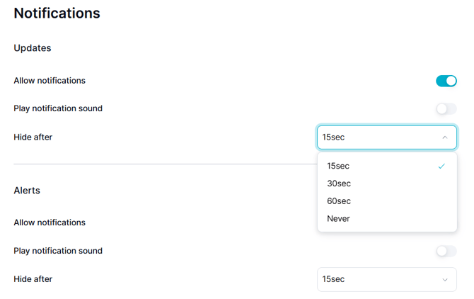
Selecting Never keeps the notification visible until you dismiss it manually.
Tip: If you receive frequent alerts, select a shorter display time to prevent notifications from remaining on your screen for too long.
In Atlas, Track Preferences allow users to personalize how vehicle/asset information, telemetry data, and location details are presented on the Track page and within the Unit Card Panel. User Settings & Preferences
Access & Scope
- Navigation: User Menu > Settings > Track Preferences (or Map and Track Preferences). Settings
- Scope: Tied directly to your individual user profile; modifying these preferences only changes your view and does not alter system-wide data or other users' views. Settings
1. Address & Location Formatting
Controls how location information is rendered across unit cards, secondary panels, coordinates tabs, and reports: Map Behaviour
- Location Name: Displays the name of defined POIs, Geofences, No-Go Zones, or Customer Locations when a unit is within them. Map Behaviour
- Street Address: Toggles the physical street address display on/off. Map Behaviour
- Latitude / Longitude: Displays raw coordinates alongside or in place of street addresses (can be toggled with or without bracket formatting: [Lat, Long]). Map Behaviour
2. Unit Card Content & Telemetry Display
Customizes which operational and telemetry metrics appear on the primary unit overview cards: Map Behaviour
- Unit Location: Displays the last known address or named location. Map Behaviour
- Last GPS Time: Shows the exact timestamp when the last GPS position fix was recorded. Map Behaviour
- Last Data Received: Displays the relative time since the device last communicated (e.g., “Updated 1 minute ago”). Map Behaviour
- Driver Information: Toggles display of the assigned driver name and profile picture on the unit card, as well as the Last Known Driver across trip panels. Map Behaviour
- Odometer & Engine Hours: Configures whether odometer values (vehicles/personal trackers) or engine run hours (assets/machinery) are visible directly on the card. Map Behaviour
- Diagnostic & Sensor Data: Controls visibility of telemetry sensors (displayed in blue). Atlas limits unit card sensors to four primary values (e.g., Primary Fuel Level/Used) to preserve scanability and reduce visual clutter. KAM Soft Launch Training Questions
- Input / Output (I/O) Status: Toggles active I/O indicators (purple icons) showing live digital and analog states. Map Behaviour
- Today's Activity Summary: Displays a summary of daily movement/trip stats on active units (automatically suppressed for inactive units). KAM Soft Launch Training Questions
3. List & Map Interaction Behaviour
- Move Active Inputs to Top: Automatically sorts units with actively triggered inputs to the top of the unit card listing. Map Behaviour
- Reset Zoom on Auto-Update: Determines whether the map view automatically reframes to fit all units when live polling refreshes. Map Behaviour
- Unit Pinning: Allows pinning critical units to remain fixed at the top of the list regardless of active filter or sort orders. Atlas - Wiki
In Atlas, Track Preferences allow users to personalize how vehicle/asset information, telemetry data, and location details are presented on the Track page and within the Unit Card Panel. User Settings & Preferences
Access & Scope
- Navigation: User Menu > Settings > Track Preferences (or Map and Track Preferences). Settings
- Scope: Tied directly to your individual user profile; modifying these preferences only changes your view and does not alter system-wide data or other users' views. Settings
1. Address & Location Formatting
Controls how location information is rendered across unit cards, secondary panels, coordinates tabs, and reports: Map Behaviour
- Location Name: Displays the name of defined POIs, Geofences, No-Go Zones, or Customer Locations when a unit is within them. Map Behaviour
- Street Address: Toggles the physical street address display on/off. Map Behaviour
- Latitude / Longitude: Displays raw coordinates alongside or in place of street addresses (can be toggled with or without bracket formatting: [Lat, Long]). Map Behaviour
2. Unit Card Content & Telemetry Display
Customizes which operational and telemetry metrics appear on the primary unit overview cards: Map Behaviour
- Unit Location: Displays the last known address or named location. Map Behaviour
- Last GPS Time: Shows the exact timestamp when the last GPS position fix was recorded. Map Behaviour
- Last Data Received: Displays the relative time since the device last communicated (e.g., “Updated 1 minute ago”). Map Behaviour
- Driver Information: Toggles display of the assigned driver name and profile picture on the unit card, as well as the Last Known Driver across trip panels. Map Behaviour
- Odometer & Engine Hours: Configures whether odometer values (vehicles/personal trackers) or engine run hours (assets/machinery) are visible directly on the card. Map Behaviour
- Diagnostic & Sensor Data: Controls visibility of telemetry sensors (displayed in blue). Atlas limits unit card sensors to four primary values (e.g., Primary Fuel Level/Used) to preserve scanability and reduce visual clutter. KAM Soft Launch Training Questions
- Input / Output (I/O) Status: Toggles active I/O indicators (purple icons) showing live digital and analog states. Map Behaviour
- Today's Activity Summary: Displays a summary of daily movement/trip stats on active units (automatically suppressed for inactive units). KAM Soft Launch Training Questions
3. List & Map Interaction Behaviour
- Move Active Inputs to Top: Automatically sorts units with actively triggered inputs to the top of the unit card listing. Map Behaviour
- Reset Zoom on Auto-Update: Determines whether the map view automatically reframes to fit all units when live polling refreshes. Map Behaviour
- Unit Pinning: Allows pinning critical units to remain fixed at the top of the list regardless of active filter or sort orders. Atlas - Wiki