Map Tools can be used to:
- Navigate around the map.
- Measure distances between points.
- Draw circular or custom areas.
- Create routes.
- Change the map view.
- Show or hide locations, geofences, no-go zones, routes, and other map information.
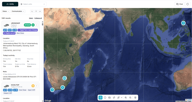
Map Navigation and Drawing Tools
The floating toolbar contains the main tools used to interact directly with the map.
Hand Tool
The Hand tool is the default map navigation tool.
Use it to move around the map and view different areas without creating or editing anything.
Draw Circle
The Draw Circle tool allows you to create a circular area on the map.
As you draw the circle, its size is displayed directly below the shape. After the circle is created, you can configure the details of the location.
This is useful when you need to define an area around a specific point.
Measure Distance (Ruler Tool)
The Measure Distance tool allows you to measure the distance between locations directly on the map.
As you create a measurement, the distance is displayed on the map and updates as additional points are added. This makes it easier to estimate distances without leaving the Tracking page.
Note: The Measure Distance tool is not available on mobile devices.
Draw Polygon
The Draw Polygon tool allows you to create a custom area by placing multiple points on the map.
This is useful for locations that cannot be represented accurately by a simple circle, such as:
- Business premises.
- Depots or yards.
- Operational areas.
- Restricted areas.
- Custom geofences.
Draw Route
The Draw Route tool allows you to create a route directly on the map.
By default, Snap to Road follows available roads when creating the route. This helps create a route that follows the actual road network.
For areas where mapped roads are unavailable or unsuitable, you can switch to Free Draw to create the route manually.
Free Draw can be useful for off-road routes, private roads, construction sites, rural areas, or other locations where the required path does not follow the standard road network.
Map Overlayers
The Map Overlayers tool controls how the map looks and which information is displayed.
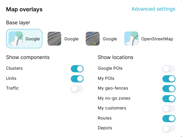
Base Map
You can change the map background to suit the information you need to see.
Available map views include:
- Road – Displays the standard road map.
- Satellite – Displays satellite imagery.
- Hybrid – Combines satellite imagery with road and location information.
Show or Hide Map Information
Map Layers can also be used to quickly show or hide information displayed on the map, including:
- Points of Interest (POIs).
- Customer Locations.
- Geofences.
- No-Go Zones.
- Routes.
Turning unnecessary layers off can make the map easier to read, especially when many locations or areas are displayed at the same time.
Additional display options are available under Advanced Settings.
Location Opacity
Location areas can be displayed with different opacity levels.
Instead of manually selecting a percentage, Atlas provides three opacity options:
- Light
- Medium
- Dark
These options help keep roads, map labels, units, and other important information visible when an area is displayed over the map.
Map Tools on Mobile
Map Tools are adapted for smaller screens when Atlas is used on a mobile device.
Some tools and interactions may work differently from the desktop version:
- Measure Distance is not available on mobile.
- Map Layers are displayed in a compact panel at the bottom of the screen.
- Information normally displayed by hovering over the map can be opened by tapping the relevant map pin.
- When multiple items are available in the same area, you can swipe through them using the information cards displayed at the bottom of the screen.
This provides access to the most important map functionality while keeping the mobile map clear and easy to navigate.